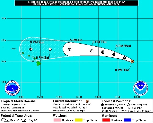
Tropical Storm Howard in the East Pacific was gradually weakening Tuesday as it moved west-northwest toward cooler waters.
Tropical Storm Howard in the East Pacific was gradually weakening Tuesday as it moved west-northwest toward cooler waters.
As of 5 p.m., the storm was 1,530 miles east of Hilo, moving at 15 mph and packing maximum sustained winds of 50 mph.
“We’re starting to keep a closer eye on it because it’s still in the Eastern Pacific, but it’s expected to cross into the Central Pacific (tonight) or Thursday morning, somewhere around there,” Maureen Ballard, a National Weather Service forecaster in Honolulu, said late Tuesday afternoon.
On Monday, Howard was forecast to weaken into a tropical depression before crossing 140 longitude, the line of demarcation between the Eastern and Central Pacific, but revised projections have the storm maintaining cyclone strength when that occurs.
“At the current track, it’s still going to be a storm when it crosses, but the last track shown (when it passes Hawaii) it’s going to be a depression,” Ballard said. “We’re still showing it as weakening as it crosses into the Central Pacific and then weakening further, but it’s always a good idea to keep an eye on it.”
Another storm appears to be organizing south of Mexico’s Baja Peninsula.
At 5 p.m. Tuesday, the disturbance known as Tropical Depression 10-E packed maximum sustained winds of 35 mph. It will be named Ivette if it, as forecast, becomes the ninth tropical cyclone of this year’s hurricane season. It is expected to reach hurricane strength sometime Thursday and remain at hurricane strength when it crosses into the Central Pacific, most likely Sunday morning.
“Our priority is, of course, to get Howard on its way, and then we’ll be taking a closer look at 10-E,” Ballard said. “We are keeping an eye on that one, as well. That’s still quite a ways out. It’s still south of Cabo (San Lucas, Mexico). But the current day-five track has it just reaching (longitude) 140 at that point.
“I hope everybody is already prepared since we’re already in hurricane season. And we’ll keep doing what we’re doing, which is keeping an eye on it. Even if these don’t (hit), we need to stay prepared, stay on top of it.”
And Big Islanders are going to get more rain, regardless, as the remnants of the former Hurricane Frank are due to arrive soon.
“It is going to bring more rain to the islands (tonight) and Thursday,” Ballard said. “And, actually, the Big Island might see it a little earlier. It might be (this) afternoon, late afternoon, that you might see an uptick in showers. We’re not looking at flooding-type rain, but we are looking at an uptick in trade wind shower activity.”
Email John Burnett at jburnett@hawaiitribune-herald.com.

